


- India’s Andaman & Nicobar Advantage: Security, Trade and the Battle for the Indo-Pacific
- From Maritime Outpost to Strategic Powerhouse
- Guarding the Malacca Gateway: Countering China’s String of Pearls
By Jai Kumar Verma
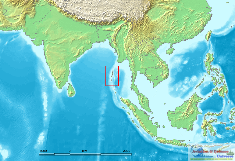
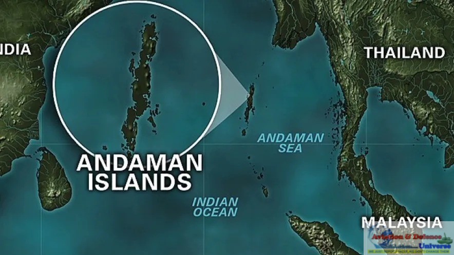
New Delhi. 18 June 2026. The Andaman and Nicobar Islands are rapidly emerging as one of India’s most strategically significant assets in the Indo-Pacific. Situated near the western entrance of the Strait of

Malacca, a vital maritime chokepoint through which a substantial portion of global trade and energy supplies pass, the island chain offers India a unique geopolitical advantage. Recognising their growing importance amid intensifying regional competition and China’s expanding presence in the Indian Ocean, New Delhi has accelerated ambitious military, infrastructure, and economic development initiatives across the archipelago. From development projects to expansion of naval and surveillance capabilities, the islands are increasingly central to India’s vision of becoming a leading maritime power and regional security provider in the Indo-Pacific.
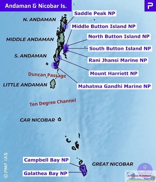
Great Nicobar Island, located close to key shipping lanes linking the Indian Ocean and the Pacific, overlooks the Six Degree Channel through which a significant share of global and Chinese trade passes. Recognising this advantage, India launched the Great Nicobar Island Development Project in 2021. The project includes a transhipment port at Galathea Bay, an international airport, township infrastructure, and a 450 MVA power plant based on gas and solar energy. The port, built at a naturally deep harbour of nearly 20 metres, is expected to handle around 4 million TEUs by 2028 and eventually 16 million TEUs at maturity. The initiative reflects India’s growing maritime and strategic ambitions in the Indo-Pacific region.
 India’s ambitious ₹81,000 crore ($10 billion) development push to transform the The Andaman and Nicobar Islands (ANI) from a relatively quiet maritime outpost into a critical military and economic hub. As of May 2026, the initiative has accelerated into a phase of high-tempo infrastructure expansion, reflecting New Delhi’s growing urgency to strengthen its strategic posture in the Indian Ocean. The move comes amid heightened concerns over China’s expanding naval footprint in the region, positioning the island chain as a pivotal node in India’s broader security and geopolitical calculus.
India’s push to strengthen its military posture in the ANI is anchored in a broader “force accretion” plan aimed at significantly enhancing the capabilities of the Andaman and Nicobar Command, the country’s only integrated theatre command. While officials have indicated a multi-year expansion of troop levels, aviation assets, and logistics, the frequently cited 2027 deadline should be viewed as indicative rather than fixed, as such defence projects typically evolve in phases. Among the most prominent proposals is the development of a dual-use international airport at Great Nicobar, often referred to as the Galathea Bay project, with an estimated cost in the range of ₹15,000 crore. Plans also include extending runways at INS Baaz and INS Kohassa to around 3,000 metres, enabling operations by larger aircraft, including maritime surveillance platforms and fighter jets.
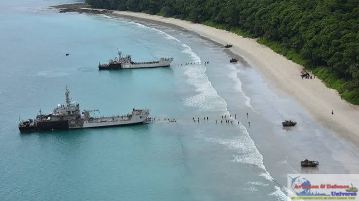
Parallel efforts are focused on expanding maritime infrastructure and improving domain awareness across the island chain. Jetties and harbour facilities are being upgraded to support larger naval vessels, such as destroyers and advanced frigates, reflecting India’s intent to sustain a stronger and more persistent presence in the eastern Indian Ocean. Surveillance capabilities are also being reinforced, though reports of a so-called “Fishhook” undersea sensor network remain largely speculative and tied to broader multinational initiatives rather than officially confirmed Indian deployments.
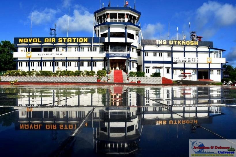 At INS Utkrosh in Port Blair, several modernization efforts have been undertaken to enhance operational effectiveness and maritime security. These upgrades reportedly include the installation of an Integrated Underwater Harbour Defence and Surveillance System, which strengthens the monitoring and protection of naval assets against underwater threats. Additionally, improvements in radar systems have been made to ensure better performance during low-visibility conditions, such as fog or heavy rain. It would strengthen and enhance the coastal security. Together, these advancements are part of a broader strategic initiative aimed at reinforcing coastal defence capabilities, improving situational awareness, and ensuring a more robust security framework in the region.
ANI occupy a critical geographic position between the Bay of Bengal and the Andaman Sea, placing them close to some of the world’s busiest sea lanes. Indian strategic documents, including the Indian Maritime Security Strategy, identify this region as a primary area of interest due to its role in safeguarding maritime trade and regional stability. The islands lie near the western approaches to the Strait of Malacca, one of the busiest chokepoints globally, through which a significant share of international trade and energy shipments passes. Their location allows India to enhance maritime domain awareness and support freedom of navigation, particularly amid concerns over China’s efforts to mitigate its so-called “Malacca dilemma.”
 The “Malacca Dilemma,” a term reportedly used by Hu Jintao in 2003, refers to China’s strategic dependence on the Strait of Malacca for trade and energy supplies. Around 75–80% of China’s imported oil and a major share of its maritime trade pass through this narrow sea lane, which is only about 2.7 km wide at its narrowest point. China imports roughly 11–12 million barrels of crude oil per day, while overland pipelines from Russia, Central Asia, and Myanmar can carry only a limited portion of this demand. Beijing fears that in any major conflict, especially involving Taiwan, hostile naval powers could disrupt these shipping routes. To reduce this vulnerability, China has invested heavily in pipelines, the China–Pakistan Economic Corridor, Gwadar Port, and alternative trade corridors. However, none of these projects can fully replace the strategic importance of the Malacca route.
China’s expanding presence in the Indian Ocean is often linked to the “String of Pearls” theory, which describes Beijing’s investment in ports and infrastructure across the region, including Gwadar in Pakistan, Hambantota in Sri Lanka, and Kyaukphyu in Myanmar. Although these facilities are officially commercial, many strategic specialists believe they could also support future naval operations. In response, India has increased its focus on the ANI, especially the Great Nicobar development project, due to their proximity to major sea lanes near the Strait of Malacca. Reports have also highlighted Chinese-linked activity on Myanmar’s Coco Islands, located north of the Andaman chain, raising Indian security concerns. India is strengthening maritime surveillance and naval infrastructure in the region to improve monitoring of Chinese naval movements in the Bay of Bengal and eastern Indian Ocean. Recent incidents involving Chinese research and survey vessels near Indian naval activity zones have further underlined the strategic competition unfolding in these waters.
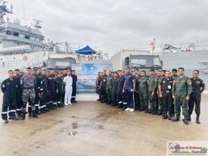
At the same time, India’s growing military and economic focus on the islands extends beyond countering China alone. It reflects a broader ambition to strengthen its role in the Indo-Pacific and deepen engagement with Southeast Asia, including through cooperation with Association of Southeast Asian Nations countries. Initiatives such as coordinated patrols and multilateral exercises like Exercise MILAN reinforce regional partnerships and operational presence. The islands are also being developed as a potential maritime and logistics hub, including plans for transhipments infrastructure. While defence planners sometimes describe the archipelago as an “unsinkable aircraft carrier,” this remains a metaphor rather than an official designation. Any future deployment of advanced aircraft or drones would depend on infrastructure readiness and evolving operational requirements, but the strategic logic of leveraging the islands’ location is widely acknowledged.
 A large share of global cargo traffic travelling between East Asia, the Middle East, Europe, and Africa passes near these islands. This geographic advantage gives India an opportunity to develop the region into a major transhipment and logistics hub in the Indo-Pacific. At present, much of India’s cargo is routed through foreign ports such as Singapore and Colombo for redistribution. Expanding port infrastructure in Great Nicobar could reduce dependence on overseas hubs, lower shipping costs, improve turnaround time, and strengthen India’s position in regional and global maritime trade networks.
The economic potential of the ANI extends beyond shipping and port activity as the ANI possess significant marine wealth. Improved connectivity, modern infrastructure, and maritime investment can stimulate growth in sectors such as tourism, rich fisheries, coral ecosystems, renewable energy, potential offshore energy resources, ship repair, and marine services. The development of a transhipment port and related logistics ecosystem could attract international shipping companies, generate employment, and encourage private investment in the region. The islands also offer opportunities for expanding India’s blue economy through sustainable use of ocean resources, including deep-sea fishing, marine biotechnology, and coastal trade. With careful planning and environmental protection, the islands could emerge as an important centre for economic activity and maritime commerce in the eastern Indian Ocean region.
The ANI are strategically positioned to support rapid disaster relief and humanitarian operations across the Indian Ocean region, especially during tsunamis, cyclones, and maritime emergencies. Their location enables faster deployment of naval and air assistance, strengthening India’s capacity to provide humanitarian aid and reinforce its role as a regional security provider.
 The Andaman and Nicobar Islands are no longer merely remote territories on India’s maritime map; they are evolving into a critical pillar of the country’s strategic and economic future. Their location near major global sea lanes provides India with unparalleled advantages in maritime security, trade connectivity, disaster response, and regional diplomacy. As geopolitical competition intensifies in the Indo-Pacific, the islands offer India a powerful platform to strengthen deterrence, enhance maritime domain awareness, and deepen engagement with Southeast Asia and global partners. At the same time, their economic potential in shipping, tourism, fisheries, renewable energy, and the blue economy could transform the region into a major hub of growth and connectivity. If developed with long-term strategic planning and environmental balance, the ANI can play a significant role in India’s maritime rise and Indo-Pacific leadership in the decades ahead.
(Jai Kumar Verma is a Delhi-based strategic analyst and Life Member of United Services Institute of India and member of The Manohar Parrikar Institute for Defence Studies and Analyses. The views in the article are solely the author’s. He can be contacted at editor.adu@gmail.com)