


New Delhi. 18 June 2020. As expected the second amendment to the constitution of Nepal which passed through the National Assembly got the Presidential seal and Nepal has now a new map on its national emblem.
“The amendment bill has been authenticated by the president as per Article 274 (10) of the constitution of Nepal,” reads a statement by Hari Prasad Dahal, spokesperson at the president’s office. All 57 voting members of the Upper House voted for the bill.
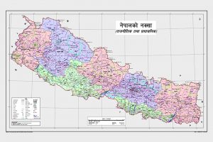
This amendment gets Indian territories of Limpiyadhura, Lipulekh and Kalapani within Nepali territory. It may be recalled that the Nepalese Cabinet, on May 20, had issued a new political and administrative map of the country. The ties between the two countries came under strain after Defence Minister Rajnath Singh inaugurated an 80-km-long road connecting the Lipulekh pass with Dharchula in Uttarakhand on 8 May. Nepal claimed all the three Limpiyadhura, Lipulekh and Kalapani as its own.
It is a personal victory for the Nepalese Prime Minister KP Sharma Oli, one which will fetch him a pat on the back from China. But it has done an irreparable damage to India-Nepal ties.