


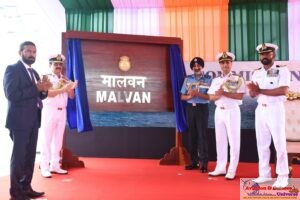


Marignane. 14 JULY 2018. The Civil Aviation Authority of Singapore, the European Aviation Safety Agency and Airbus have agreed to collaborate in the development of safety standards and regulatory requirements for unmanned aircraft systems in urban environments. The tripartite Project Document, which lays out the areas of collaboration, was signed by representatives from CAAS, EASA and Airbus.
The Project Document establishes a framework for the exchange of information and technical expertise among the three parties, to facilitate the development of safety standards and regulatory requirements, as well as operational and technological assessments for the deployment of UAS in urban environments, such as last-mile deliveries, leveraging Airbus’ experience with the ongoing Skyways project1. The parties will also share safety information and learning outcomes from the urban UAS trials. The parties also agreed to jointly organise UAS-themed activities such as educational workshops and seminars.
Mr Kevin Shum, Director-General at CAAS said, “This tripartite partnership is timely as we seek to better define the operating conditions for the growing number of beneficial uses of UAS in urban environments such as Singapore, with aviation and public safety in mind. We look forward to working closely with our partners and sharing our experience gained thus far in developing regulatory requirements for UAS operations in Singapore.”
Mr Patrick Ky, Executive Director at EASA said, “Unmanned Aircraft Systems used in urban environments will shape the future of public transport. We could not find better partners than CAAS and Airbus to develop safety standards for this growing and fascinating technological development.”
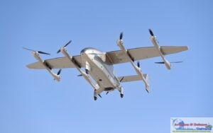
Mr Jean-Brice Dumont, Executive Vice President, Engineering at Airbus said, “Airbus has been growing our focus on autonomous air mobility, and this tripartite collaboration is a positive move to shape up the safety regulations of UAS in city environments, turning urban air mobility into a business reality for us. Today, our Skyways UAS has demonstrated its ability to deliver air packages in an urban city. With the strong support of both CAAS and EASA, coupled with our experiences from Skyways, we are confident that safe and reliable urban air delivery will become a reality very soon.”
Skyways is an Airbus’ experimental project which aims to establish seamless multi-modal transportation networks in smart cities. Through Skyways, Airbus aims to develop an airborne infrastructure solution to address the sustainability and efficiency of parcel delivery businesses in large urban environments.
As part of the contract, six million square kilometres over 39 countries will be covered in 2018 with freshly acquired very high-resolution optical satellite imagery. The result-based approach of the procurement has led European EO industry to federate and respond with a coordinated offer bringing together the strengths of each partner. The contracted solution leverages the latest in remote sensing and imagery processing technologies to deliver new data at an unprecedented scale and speed. The data will feed the geo-information services coordinated by the European Environment Agency with which European institutions and governments implement their environmental and land management policies.
“This contract shows the confidence of ESA in Airbus and its partners to fulfill such a demanding satellite imagery programme,” said François Lombard, Head of the Intelligence Business at Airbus Defence and Space. “We are very proud to drive a consortium gathering such a unique combination of assets and together, we are confident we will deliver high quality full European coverage in record time.”
The high revisit rate of Planet’s imaging system will allow it to image regions that are often covered in cloud, such as Northern Europe or the Alps, while Deimos Imaging and Airbus satellite resources will concentrate on Southern and Central Europe, where higher resolutions are required to map dense urban and suburban areas. A dynamic acquisition strategy and imaging redundancy within the consortium will guarantee the achievement of the coverage objective. Valid images, cloud and haze free, will be selected and combined with a specific Digital Elevation Model (DEM) in order to meet the European Commission and ESA geolocation accuracy specifications.
“This is an important partnership for Planet as it brings together major players in the private and public sectors to leverage our global, daily imagery to do something that has historically been very difficult to achieve,” said Will Marshall, CEO and cofounder of Planet. “Europe is very much ahead of the curve in terms of public-private cooperation and turning data into a public good, and we’re proud to be a part of this.”
“We are very excited to be part of this landmark project,” said Fabrizio Pirondini, CEO at Deimos Imaging. “Our company has enjoyed a long, successful history of supplying satellite products and services to European public entities, such as ESA and EMSA. This contract, one of the largest we have been awarded in our history, demonstrates the value of our partnerships, as well as our increasing role as a key provider of imagery and geo-information products worldwide.”
This dataset will be available to institutional users on a European and national level, and it will serve to create updated information about land cover, as well as land use (for example forests, urban areas, or lakes and rivers) over 39 countries in Europe.


-A4-Size-(2)_page-0001.jpg)