


Pittsburgh, PA — March 5, 2026 — Astrobotic, in partnership with Carnegie Mellon University (CMU), has successfully completed Phase II of its NASA Small Business Technology Transfer (STTR) project for Distributed Agent Localization Estimation for spaceCraft (DALEC), advancing the system from Technology Readiness Level (TRL) 3 to TRL 5. DALEC is designed to provide positioning, navigation, and timing (PNT) capabilities in environments where GPS is unavailable, including the lunar surface.
DALEC helps spacecraft, autonomous vehicles, rovers, and astronauts understand where they are and where other assets are relative to them. Each asset uses its own onboard sensors such as cameras or laser scanners to estimate its position. That information is then shared wirelessly with nearby assets and combined using distributed algorithms to produce more accurate and reliable localization across the group.
“Reliable positioning, navigation, and timing is foundational for shared infrastructure that multiple missions can rely on,” said Sean McGill, Senior Project Manager at Astrobotic. “DALEC supports the kind of interoperable navigation capability needed as lunar infrastructure scales and missions become increasingly interconnected. This work combines embedded systems development with advanced algorithms to address problems that single-sensor approaches cannot solve.”
This collaborative approach allows multiple assets to operate as a coordinated system, sometimes described as a swarm. Working together, DALEC-enabled assets can map unknown terrain, navigate rough or poorly lit areas, plan safer routes, and coordinate tasks such as science operations, resource prospecting, construction activities, or exploration of caves and lava tubes. These capabilities are particularly important for future Artemis missions, where astronauts, vehicles, and robotic systems must operate together across large areas of the lunar surface.
Alignment With Distributed Lunar Infrastructure
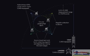
DALEC is intended to serve as a core localization and mapping capability within a broader autonomous agent framework and aligns with lunar infrastructure solutions such as Astrobotic’s LunaGrid architecture. By enabling interoperable, low-bandwidth sharing of navigation data among assets, DALEC supports the development of distributed PNT infrastructure that can scale as more systems operate simultaneously on the Moon.
The system combines visual odometry and other onboard sensing with ultra-wideband radio frequency ranging between agents. This fusion of sensing modalities provides robustness when individual sensors are degraded, such as in areas with uniform terrain, changing lighting conditions, or partial sensor failures. DALEC is designed as a flexible, low size, weight, power, and cost sensor package that can be integrated onto a wide range of lunar assets and communicate with any other DALEC-enabled system.
Testing in Relevant Environments
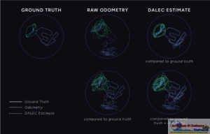
During Phase II, Astrobotic and CMU demonstrated the fully integrated DALEC system in simulation, an indoor laboratory environment, and an outdoor lunar-like test environment. Outdoor testing was conducted in a quarry selected for its rough, rocky terrain and open layout, providing a relevant analogue to lunar surface conditions. Demonstrations included multiple mobile agents and stationary landmarks sharing data over a low-bandwidth mesh network, validating the system’s distributed localization algorithms and embedded electronics platform.
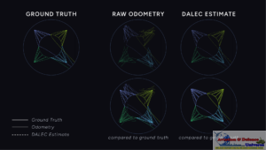
Key Phase II results include decentralized multi-agent localization that significantly improves position estimates compared to non-collaborative approaches, robustness to sensor dropouts, stable real-time software running on embedded Linux hardware, drop-in and drop-out capability for agents joining or leaving the network, and successful operation with minimal communication bandwidth. The project also produced multi-agent simulation tools with realistic sensor and communication modeling.
The two-year Phase II effort concluded in January, meeting TRL 5 requirements. Astrobotic is evaluating next steps to further mature DALEC and explore its path toward a deployable product supporting future lunar missions and distributed PNT infrastructure.