


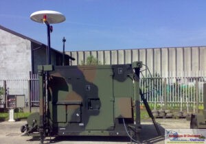
Madrid, 24 July 2018. Under a contract with the European Space Agency (ESA), Indra is developing an innovative terminal designed to enable governments, organizations and companies to directly and autonomously retrieve data from earth observation satellites and get extremely high-resolution images virtually in real time.
They will only need two main elements: an antenna to download the telemetry sent by satellites and this innovative Direct Access Terminal (DAT), which will process the data received to generate images with maximum celerity. After signing agreements with satellite operators, users will be allowed to independently connect to satellites, thus rendering the entire process of retrieving information of interest more agile and a matter of minutes from the data acquisition.
It was conceived so that any organization or company seeking to monitor a situation in any part of the world can do so whenever it wants. The enormously valuable images can have resolution sizes that are in many cases smaller than one meter per pixel: this is the case of ESA’s several radar satellites (SAR) that reach up to 0,25 meters per pixel. Radars allow to colletimages at night and regardless of cloud cover or weather conditions that might otherwise reduce visibility.
The degree of detail of those images suffices to identify a vessel at sea or vehicle anyplace on the planet. They can help detect and monitor spreading wildfires. They can delimit zones affected by flooding or buildings that have been damaged following an earthquake. Among the seemingly endless possibilities, they are the most effective and quickest way to examine the conditions of crops across a country and estimate cereal harvest yields for the year, or containers stored in customs-free zones at ports.
Indra’s system reduces the elements necessary to access this powerful observation capability to the absolute minimum. This capability had thus far only been within the reach of satellite operators equipped with expensive and sophisticated infrastructures that include control stations deployed around the globe and huge data processing centers. Indra’s terminal nevertheless lets end users get access to only the functional features they really need.
Indra’s terminal has been initially conceived to receive data from Spain’s PAZ radar satellite and the twin systems, TerraSAR-X and TamDEM-X, which will soon begin operating jointly as a single constellation capable of observing any point on the Earth.
Indra has designed the system to be easily adaptable for receiving and processing data from other satellites. This renders Indra’s system as one of the most advanced and versatile solutions on the market. In less than 15 minutes from the data acquisition, users can get the image of the constellation that they need. The system’s daily surveillance capability will cover an area of approximately 300,000 km2, which is equivalent to 60% of the size of Spain.
This innovative solution was developed under ESA General Support Technology Programme (GSTP), within Element 2 “Make” dedicated to commercial technologies and products, from the accumulated fruits of Indra’s hard work and dedication in some of the world’s most ambitious space projects. The company has been working for over 30 years as a trailblazer in deploying Satellite Ground Segments and space data processing centers.
For example, the company has implemented the network of stations for managing the Galileo satellites, the European global positioning system that will become one of the largest satellite navigation constellations in orbit by 2020 with a total of 30 satellites operating in full coordination. It also implemented the stations that will send the satellites messages on which the precision of the entire system depends, essential data enabling them to compare onboard clock information and orbital positioning: an error of only one billionth of a second in the information would cause a position error of 30 cm in Earth-based user systems, which is too high for critical services such as air navigation.
More recently, the company led the complete Ground Segment deployment of the Paz satellite, Spain’s first radar satellite. A distributed Ground Segment at the facilities of the Spanish Institute for Aerospace Technology (INTA) and the Aerospace Observation Systems Centre (CESAEROB) in Torrejón de Ardoz, with a third backup component in Maspalomas (Canary Islands). Indra is now leading the land Ground Segment deployment for the Ingenio optical satellite, which Spain will soon launch into space.


-A4-Size-(2)_page-0001.jpg)