


- Automatic Geo-Mapping
- The pioneering company will showcase its range of innovative 3D simulation, AI training and geo-mapping systems at the upcoming Computer Vision and Pattern Recognition Conference in Nashville.
 Petach Tikva, Israel – June 1, 2025 – Tiltan Software Engineering Ltd., a global leader in simulation, 3D engines and geo-mapping systems, is set to showcase its latest range of computer vision solutions to the upcoming conference in Tennessee. At the forefront of Tiltan’s portfolio is Majestic.ai, their flagship, multi-sensor simulation solution that delivers ultra-realistic “synthetic data” to accelerate and enhance AI/ML model training and validation.
AI training and validation for visual operations across space, aerial, maritime and land domains is both complex and resource-intensive. Whether a drone is required to identify objects or an unmanned ground vehicle (UGV) is required to navigate autonomously, these systems rely on robust AI/ML engines capable of perceiving, computing and operating within dynamic 3D environments. Training such systems demands massive amounts of data across different angles, backgrounds, resolutions, sensor types and environmental conditions. Yet real-world data is often scarce and missing critical edge cases like low visibility, cluttered environments, or camouflaged and fast-moving objects—that are hard to capture but essential for reliable performance; in many cases, privacy restrictions, confidentiality, or operational constraints mean that this data simply doesn’t exist. In addition, these processes require weeks of manual labor – data collection and manual annotation – so that AI models can effectively “learn.” It is no surprise then that this labor-intensive and time-consuming process significantly slows development and drives up costs for generative AI training and testing.
Tiltan’s Majestic.ai, directly addresses these challenges by generating high-fidelity, sensor-realistic, ready-to-use “synthetic data” at scale. Offered as DaaS (Data-as-a-Service), it operates as a core technology and an AI development enabler. Based on its proven and precise physics-based 3D engine (“TOPS”), the technology simulates real-world, outdoor scenarios (entire scenes and environments) across all domains – land, maritime, aerial and space domains. Majestic.ai covers all sensor types and spectrum ranges – from visible light to thermal IR (Infrared), LiDAR (Light Detection And Ranging) and SAR (Synthetic Aperture Radar – a high-resolution satellite imaging system). The photorealistic, physics-based video and imagery datasets it provides, validated and approved by leading defense companies and agencies, are arguably the most accurate in the market – the system’s ability to replicate IR imagery with an accuracy of 95%+ serves as an example of its true sensor realism. Another key benefit is its provision of widely diverse and balanced datasets with automatic annotation and metadata, detailed classification and segmentation, depth maps, materials and custom data.
By replacing scarce or costly real-world videos and images with carefully annotated, precision synthetic datasets, Majestic.ai enables data scientists, researchers and developers to focus on its core role of AI/ML engine development – even when real-world data is out of reach. The technology reduces training and validation costs, accelerating R&D and significantly shortening delivery time, all while ensuring improved model accuracy, with faster and more reliable AI performance for the end product. Majestic.ai supports generative AI developers, software companies, system integrators and end users – including defense and aerospace, technology, startups and research institutes focused on counter-UAS, electro-optics, computer vision, autonomy and sensor-based AI systems. The system is also implemented as part of Tiltan’s TOPS 3D simulation engine to provide a comprehensive solution for training and validating systems, including System-In-the-Loop and Hardware-in-the-Loop applications (SIL and HWIL).
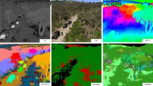
Another notable offering in Tiltan’s impressive product line is its Automatic Geo-Mapping (AGM) system, which delivers Near Real-Time (NRT), high-resolution and high-fidelity mapping, a GIS (Geographic Information System) and digital twin 3D reconstruction solution (pixel-level, highly accurate virtual representations of physical objects). The system is source-agnostic and multi-domain, utilizing data from single or multiple satellite, aerial or drone and across all types of sensors and spectral ranges (visual and thermal). AGM features detailed 3D vectorization and volumetric classification as well as DSM (Digital Surface Models) and DEM (Digital Elevation Models). The system is highly versatile, with an API, open architecture and customized workflows and, while having a GUI, can also come in the form of an SDK for enhanced customization. AGM is deployable on-site, as a cloud service or on edge computing. Rapidly converting raw spatial data for unlimited area sizes into reliable, actionable insights, AGM is well-suited for companies and entities that work with drones, aerial and satellite data, not to mention end users such as municipalities, states, intelligence agencies and tactical and strategic forces. When it comes to drone systems in particular, it enjoys a notable advantage, operating on Ground Control Stations (GCS), utilizing only CPU.
“With a growing need for our products and customer base across Europe, Asia and the U.S., we’re proud to present our latest solutions at CVPR 2025,” said Ehud Shafir, Tiltan’s acting CEO. “Backed by three decades of experience and deep domain expertise, we continue to push the boundaries of computer vision and computer graphics, delivering trusted, high-fidelity tools that accelerate AI development and boost operational performance across diverse, critical sectors.”
Tiltan will present Majestic.ai, AGM and its other products at the upcoming CVPR 2025, taking place at Music City Center, Nashville Tennessee, 11-15 June, 2025 (booth #1619). Visitors and delegates are encouraged to reach out in advance to schedule an in-person meeting.