


- The UAV, which collects samples and analyzes water quality in real time, will be ready for launch onto the market this year
- It is a drone with a maximum take-off weight of 25 kilograms, easy to use and transport, which will multiply the number of samples that can be collected
- Indra is also working on an unmanned vessel that will have a robotic system to monitor water quality in sea and oceans
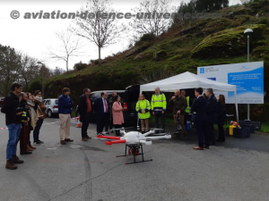
Madrid. 15 January 2020. Indra in a temporary joint venture with the Galician companies Sixtema and Adantia, has successfully tested the first environmental drone that automates the collection of samples in rivers and coastal areas and offers real-time information on water quality parameters. The system will be ready for launch onto the market this year.
This innovative solution, designed to reinforce the security and protection of natural resources, is part of the Mar 2 project of the Civil UAV Initiative, the initiative promoted by the Regional Government of Galicia (Spain) to make Galicia a leader in the development of civil drones.
The demonstration took place on January 8 at Eiras reservoir, which supplies drinking water to Vigo and other towns in the area. The test was attended by the Minister of the Xunta de Galicia for Infrastructure and Mobility, Ethel Vázquez, and the Economy, Employment and Industry Minister, Francisco Conde, as well as Patricia Argerey, director of the Galician Innovation Agency.
Within the scope of the project, Indra has been responsible for the development of automatic devices for capturing samples and data, in collaboration with the Galician company Aeromedia.
The system will help the Xunta de Galicia to control the quality of the region’s water and preserve river and coastal ecosystems.
It will multiply the number of samples that can be collected and will provide unprecedented speed in the detection of any spillage or anomaly.
It will also facilitate the collection of samples in places that are difficult to reach, reinforcing the safety of the professionals involved in these tasks.
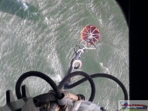
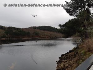
The unmanned aerial system is based on a multirotor with a maximum take-off weight of 25 kg, whose control system has been optimized. It has several devices and sensors to automatically determine the depth and state of the bottom of rivers and the coastal seabed, measure the height of the photic zone (that in which sunlight penetrates), capture and exploit in real time water quality data and take samples, both at specific depth levels and throughout the entire photic zone.
The new drone is a unique system, distinguished by integrating a large number of capacities into a small device, easy to transport and operate.
It makes it possible to collect data and samples without having a boat available immediately. Using it saves time and will offer much more accurate water monitoring.
The MAR 2 project for the Automation of Oceanographic Sampling through Unmanned Vehicles is part of the “Solutions” program of the Civil UAV Initiative, in which high- technological products and services that can reach the market and be commercialized quickly are developed.
Within the scope of this initiative, Indra is working in collaboration with the Galician companies Seadrone and the Galician Technology Center AIMEN in another project that will improve the collection of data and samples in coastal and oceanic waters.
It is an optionally manned ship that will have a robotic system to capture data and water samples and their subsequent processing. This system will be able to collect, classify, label, store and automatically conserve all samples.
This makes it possible to maintain surveillance of very large sea areas and collect high-quality information at a reduced cost.
Indra is also the company that the Spanish government has nominated to coordinate Spanish participation in FCAS, the most ambitious European program for the development of a system of systems based on a next-generation aircraft that will fly alongside several UAVs.