


- Defence adoption of indigenous tech strengthens emergency response in Himalayan terrain
 All India: An Army rescue operation combining human effort and technology introduced a new model for disaster response in remote, high-risk areas.
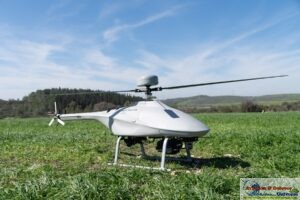
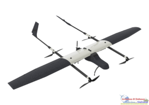
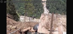
This was evident during the landslides in Lachen on 1 June 2025, about 123 km from Gangtok, where three soldiers lost their lives and six went missing. To support the search in treacherous conditions, the Indian Army deployed a Ground Penetrating Radar (GPR) drone from BonV Aero, a deep-tech startup based in a Tier II city.
Typically, high-altitude rescue involves SDRF teams, manual digging, sniffer dogs, and ground-based GPR equipment. These are often slow and dangerous. In Lachen, however, the UAV scanned the debris from above, identifying underground anomalies that guided search teams to precise locations. The drone picked up two anomalies at depths of 0.76 m and 0.015 m. Excavations at both points confirmed human remains, eliminating the need for wider, manual digging.
“The Indian Army’s swift deployment of our technology within 24 hours of the disaster reflects a growing trust in homegrown innovation. We are happy to see when a solution built in one part of the country is used meaningfully in another, exactly when it’s needed,” said Satyabarata Satapathy, CEO, BonV Aero.
“The emergency response in Lachen showed that startups like ours can play a vital role when timing, purpose, and national need align,” he added.
The drone transmitted real-time data to a digital map, helping rescue teams act swiftly. “Unlike thermal cameras or canine units, which fail when victims are buried deep or terrain is unstable, this drone safely scanned difficult areas without disturbing the site,” said Abinash Sahoo, CTO, BonV Aero.
For Army engineers, it offered more than aerial visuals—it delivered sub-surface data, adding a critical layer to situational awareness.